
The APES Atlas: A Platform for Monitoring Great Ape Conservation
Categories: Journal no. 72, Censuses, Eastern gorillas, Western Gorillas
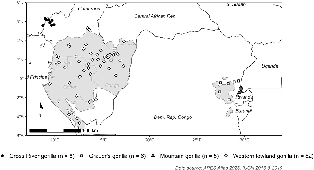
Distribution of sites in the APES Atlas where gorillas are present
The APES Atlas was created in 2018 to centralize information on apes worldwide. It is an open-access plat-form that provides site-level information on ape population status, threats, conservation efforts, and research activities. Sites include protected areas (e.g., nature reserves and national parks) and non-protected areas (e.g., concession areas, community forests). The Atlas compiles information from scientific publications, reports, and expert knowledge. These data are standardized and regularly updated, enabling large-scale assessments, such as IUCN Red List assessments, and monitoring of long-term trends in population size, threats and conservation interventions. A key objective of the APES Atlas is to support ape conservation by building a robust, evidence-based foundation for decision-making.
With contributions from more than 70 experts, the APES Atlas is a collaborative initiative, covering over 350 sites worldwide, including 70 gorilla sites as of January 2026 (see figure; APES Atlas 2026). Here, we summarize the threats and conservation activities reported at those sites between the years 2015 and 2025.
APES Atlas Gorilla Sites
Gorillas illustrate both the value and the challenge of compiling conservation data at very different spatial scales. Subspecies such as Cross River, mountain, and Grauer's gorillas occupy relatively small, well-defined ranges, allowing for highly detailed taxon-wide information. At broader geographic scales, such as the western lowland gorilla range, the proportional coverage is currently lower, so taxon-wide patterns are summarized through aggregated data rather than site-level detail.
Across all gorilla sites, the APES Atlas highlights a consistent set of major threats, with hunting emerging as the most widespread, followed by logging, agriculture, and mining. Disease, collection of non-timber forest products (NTFPs), and infrastructure development - including roads and built-up areas - also represent significant threats across many sites. These threats can have compounding effects and are often reported together; for example, infrastructure development facilitates access to previously remote forests, leading to both habitat loss and increased poaching rates (Strindberg et al. 2018).
The relative importance of these threats certainly varies by taxa and socio-ecological context. For instance, mountain gorilla populations, which are restricted to small areas surrounded by high human population densities, are highly exposed to a diverse set of anthropogenic pressures. The risk of disease transmission is high, alongside threats from human disturbance, including recreational activities and armed conflict. Their limited range also increases their vulnerability to climate-related and ecological threats. Grauer's gorillas are notably threatened by mining across much of their range, consistent with reports of widespread artisanal mining controlled by armed groups and associated with hunting and illegal bushmeat trade (Plumptre et al. 2016). In contrast, Cross River gorillas are primarily threatened by hunting, logging, agricultural expansion, and the collection of NTFPs.
The most frequently implemented conservation activities include anti-poaching measures (e.g., patrols, bushmeat market inspections and snare removal), area-based protection (such as the establishment of national parks) and education and awareness initiatives. Although agriculture is reported as a major threat, relatively few gorilla sites report conservation actions specifically designed to mitigate its impacts, such as strategies to deter gorillas from crop fields or to promote more intensive farming in designated areas. This does not imply that broader and more commonly implemented interventions, including area protection, awareness-raising, and monetary or non-monetary incentives, are ineffective in reducing agricultural pressures. Notably, mountain gorilla sites report the implementation of all categories of conservation activities across nearly all sites, reflecting both the diversity of threats affecting these populations and the range of efforts required to address them. In particular, veterinary interventions and daily monitoring have been shown to contribute substantially to the successful recovery of mountain gorilla populations (Robbins et al. 2011).
Challenges in Data Collection across Gorilla Ranges
Collecting data across the geographic range of gorillas is inherently challenging, as populations occur in remote areas where access is constrained by logistical limitations, security concerns, and ongoing threats such as poaching, illegal logging, mining, and civil conflict. These realities lead to uneven data coverage, particularly in areas where sustained monitoring has been difficult. Consequently, spatial and temporal data gaps exist in the APES Atlas. Despite these limitations the APES Atlas represents the most comprehensive resource for standardized synthesis of gorilla conservation status and threats currently available, bringing fragmented field data together in a platform that supports conservation assessments and action. Where ranges are small and populations discrete, the APES Atlas can support detailed conservation planning; where distributions are extensive, it enables regional synthesis and strategic prioritization.
How to Contribute to the APES Atlas
The APES Atlas is designed to evolve through the addition of new site information, ongoing data refinement, and strengthened collaboration. By engaging researchers and practitioners, it captures local knowledge and connects field-based efforts to regional and global conservation assessments.
We encourage the readers to explore the APES Atlas (www.apesatlas.iucnapesportal.org) and contribute their knowledge and conservation experience, increasing the visibility of their work while strengthening the Atlas as a shared, open resource for guiding and monitoring gorilla conservation. Feel free to contact us at inemeth[at]rewild.org and amizero[at]gorillafund.org.
Isabel Ordaz-Nemeth and Aime Mizero Bazina
References
APES Atlas (2026): IUCN SSC APES Atlas. Online: apesatlas.iucnapesportal.org
IUCN (International Union for Conservation of Nature) (2016): Gorilla gorilla (spatial data). The IUCN Red List of Threatened Species. Version 2025-2. www.iucnredlist.org. Accessed 10 March 2026
IUCN (International Union for Conservation of Nature) (2019): Gorilla beringei (spatial data). The IUCN Red List of Threatened Species. Version 2025-2. www.iucnredlist.org. Accessed 10 March 2026
Plumptre, A. J. et al. (2016): Catastrophic decline of world's largest primate: 80% loss of Grauer's Gorilla (Gorilla beringei graueri) population justifies critically endangered status. PloS one 11 (10), e0162697
Robbins, M. M. et al. (2011): Extreme conservation leads to recovery of the Virunga mountain gorillas. PloS one 6 (6), e19788
Strindberg, S. et al. (2018): Guns, germs, and trees determine density and distribution of gorillas and chimpanzees in Western Equatorial Africa. Science advances 4 (4), eaar2964