
The Conservation of Itombwe Nature Reserve
Categories: Journal no. 51, Protective Measures, Democratic Republic of the Congo, Itombwe, Grauer's Gorilla, Gorilla Journal
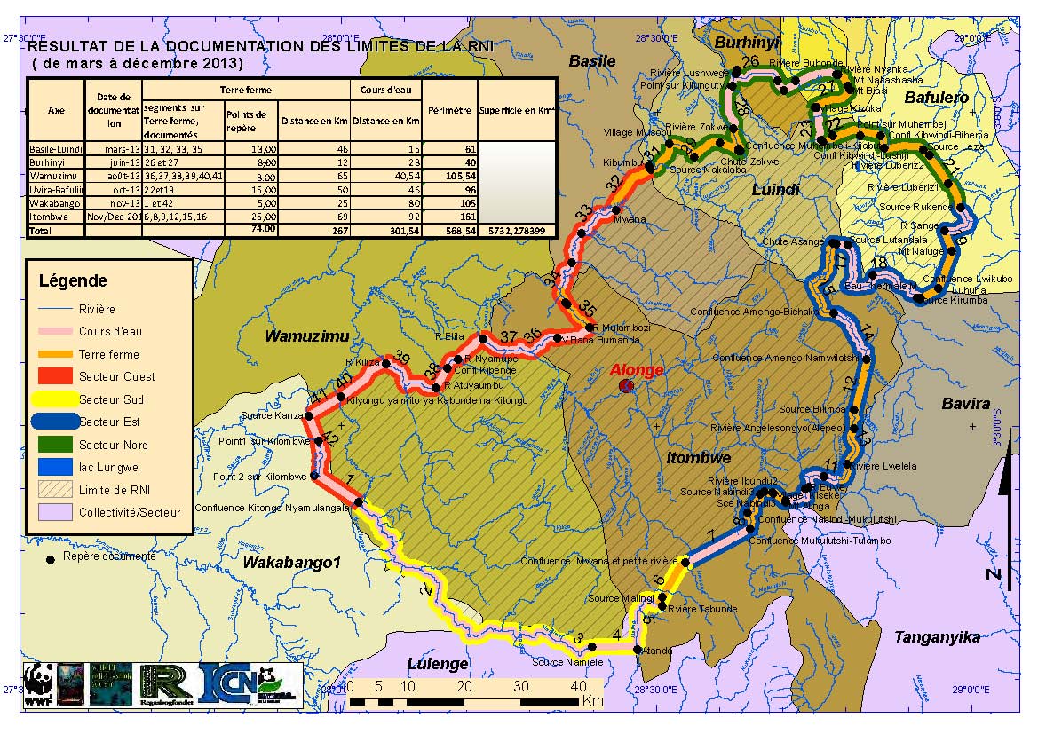
Map of the Itombwe Nature Reserve, representing Scenario 5 with some sections of the boundary (© Deo Kujirakwinja)
Itombwe Nature Reserve (INR) is a key site for biodiversity in Africa in general and the region of the Albertine Rift in particular (Doumenge & Schilter 1997; Hart et al. 1999; Plumptre et al. 2007; Greenbaum & Chifundera 2012). The reserve is part of the exceptional high-altitude forests extending from 1,500 m to over 3,000 m altitude (Mubalama et al. 2008). According to different biological expeditions into the massif, the site remains important for biodiversity both due to the number of endemic species (endemism) and for the number of species in general (species richness), especially due to recent re-discoveries of certain amphibian species (Plumptre et al. 2010; Greenbaum & Chifundera 2012). However, in spite of its biological richness and habitat diversity, the biodiversity of the massif is threatened by various human activities. These include hunting using traditional means or firearms, small-scale and industrial mining, lighting of bush fires to facilitate grazing by domestic animals, human settlements and the weak governance of natural resources (Plumptre et al. 2010, 2013; Weinberg et al. 2013).
In order to find solutions for the challenges facing conservation of the massif, conservation stakeholders involved in the INR have put into place an integrated intervention plan which covers a range of activities from consultations with the local population to activities to protect the reserve's biodiversity (Mubalama et al. 2013). This paper will present the planning process, the different threats to biodiversity in the Itombwe Nature Reserve, the conservation efforts made by various stakeholders and the challenges that need to be overcome.
Location of the Itombwe Nature Reserve
The INR is situated in the east of the Democratic Republic of the Congo (DRC) in South Kivu Province, west of Lake Tanganyika. It extends between 2° 51.286' and 4° 0.690' south, and between 28° 09.889' and 28° 58.511' east. The Itombwe Mountains are part of the Mitumba Range in the east of the DRC in the Albertine Rift. The Mitumba Range borders the western branch of the Great Rift Valley, with several large lakes covering the valley floor (Doumenge & Schilter 1997).
The range is part of what is known as the Itombwe Massif and it is covered by a vast mountain forest. In fact, it is part of a mountain range that extends along the entire eastern border of the DRC, from Katanga to North Kivu (Doumenge & Schilter 1997; Mubalama et al. 2008). The Itombwe Massif has the largest high-altitude forest in the whole of Africa. Of the massif's 15,000 km², over 7,500 km² are covered by forest. Almost all of this (over 6,700 km²) is high-altitude forest, including transition and bamboo forest. Itombwe's vegetation is very varied, ranging from low altitude to the highest summits (Doumenge & Schilter 1997; Mubalama et al. 2008).
The current attempt to demarcate the reserve boundaries is the result of field work conducted within a joint framework developed through a participatory process that has focused on the identification and the validation of current maps (Mubalama et al. 2013; Plumptre et al. 2013). The current reserve boundaries give the reserve a surface area of 5,732 km², with a perimeter of 568 km (Mubalama et al. 2013). It extends into the territories of Mwenga, Uvira and Shabunda.
Currently, the reserve is managed by the Congolese Institute for Nature Conservation (ICCN). Conservation activities here are supported by Wildlife Conservation Society (WCS), the Worldwide Fund for Nature (WWF) and Africapacity/Rainforest Foundation Norway (Plumptre et al. 2010, 2013; Mubalama et al. 2013).
Participatory Process for the Validation of the Reserve Boundaries
The process of creating protected areas in the DRC has paralleled the evolution of conservation in the rest of the world (Hockings et al. 2000; Palomo et al. 2014). Protected areas were originally created by governments with little or no consultation of local communities or other stakeholders (Stevens & Stevens; Wells & McShane 2004). This top-down approach can be seen as being the root cause for the weak support by stakeholders at different levels (Kideghesho 2002; Fisher et al. 2012).
In the case of Itombwe, the reserve was created by ministerial decree no. 038/CAB/MIN/ECN-EF/2006 of 11 October 2006. This decree did not include an identification of boundaries and had little community buy-in (Plumptre et al. 2009, 2013; Greenbaum & Chifundera 2012; Mubalama et al. 2013). This was at the bottom of a certain resistance by local communities and other groups to the implementation of conservation activities (de Failly & Bandu 2010).
In order to minimise conflicts between different actors and to ensure ownership of different stakeholders of the process of boundary demarcation, the ICCN and its partners, in collaboration with Africapacity/Rainforest Foundation Norway and the South Kivu civil society, developed a joint intervention approach with the aim to coordinate the different activities to be implemented and to ensure the involvement of the stakeholders at different levels (Plumptre et al. 2009, 2013; Mubalama et al. 2013).
The preliminary steps taken prior to 2006 (Prigogine 1977; Doumenge & Schilter 1997; Hart et al. 1999; Keyo & Yma 2000) included biological surveys, socio-economic studies, and meetings with local communities and tribal chiefs. Additional measures initiated to ensure participation are summarized below (for details, please refer to the paper by Mubalama et al. 2013 on the joint framework):
Meeting of Stakeholders Interested in the Conservation of the Itombwe Massif
The process of creating protected areas in the DRC has been adapted and modified by Law no. 011/2002 of 29 August 2002 (Article 15 contains the DRC 2002 Forestry Code), and Decree no. 08/08 of 8 April 2008. In Article 8, Line 1, this Decree outlines the procedure for forest categorization and recategorization including the recommendation that consultations are held before the forest is categorized. In order to preempt any misunderstandings accompanying the signature of the decree, a harmonisation meeting was held with different groups and civil society organisations (de Failly & Bandu 2010; Kujirakwinja et al. 2010; Mubalama et al. 2013).
At the conclusion of this meeting, the different stakeholders pledged to support the process of demarcation of the Itombwe Nature Reserve. A joint framework for the coordination of activities was identified to ensure the involvement of the various stakeholders as below (Kujirakwinja et al. 2010; Damman & Hofsvang 2012; Mubalama et al. 2013):
- ICCN, being the state authority charged with the conservation of the reserve,
- the international conservation NGOs: WCS and WWF,
- a national NGO with the support of an international institution concerned with the rights of indigenous peoples, Rainforest (Africapacity),
- civil society organisations representing the various social groups.
A Joint Framework Is Established for the Itombwe Nature Reserve
A joint framework (as presented above) was established with the role of designing, coordinating and ensuring the implementation of activities (Damman & Hofsvang 2012; Mubalama et al. 2013). In order to ensure that the various stakeholders remain involved in the process, the joint team produced a plan of activities to be carried out before the boundary validation. This plan has been presented to and been modified by local interest groups. Planning meetings were held in different places and adjustments were made. This approach resulted in the involvement of the different stakeholders and in the re-establishment of trust between participants (Damman & Hofsvang 2012).
Development of a Reference Map for the Validation of Reserve Boundaries
Based on biological and socio-economic data collected in the field, a baseline map was developed to initiate the discussions (Damman & Hofsvang 2012; Mubalama et al. 2013; Plumptre et al. 2013). As the community has opted for a biosphere reserve, where biodiversity should be conserved at the same time as the livelihoods of the local communities are improved, a map showing different zones has been produced (Bisidi et al. 2008; Plumptre et al. 2009, 2010). In the course of its development, the map underwent various modifications. The maps resulting from this process were considered as different scenarios. The final and current map is known as "Scenario 5".
Validation of Reserve Boundaries at the Community Level
The maps were presented to the communities that live in and around the reserve and to the local authorities. Sessions were held at the level of different village groupings with the objective to validate the proposed boundaries on the maps, taking into account biological and socio-economic needs (Bisidi et al. 2008; de Failly & Bandu 2010; Mubalama et al. 2013). These boundaries were accepted at the various localities, in some cases without amendments and in some cases with significant modifications in line with the cultural needs and the biological values identified by the communities. This was the case of Lac Lungwe. Situated at 2,700 m above sea level, it includes some forests on the western border of the reserve. In contrast, in two other village groupings, the communities reserved judgement on the reserve boundaries depicted in Scenario 4 as they were not yet sufficiently sensitized. This has taken the map into Scenario 5 which excludes the forests of Lulenge and Kasanza in order to ensure that the principle of free, prior and informed consent (CLIP) is respected (Kujirakwinja et al. 2010; Mubalama et al. 2013; Plumptre et al. 2013).
The process of participatory demarcation of the INR was adopted as a new conservation paradigm. It was put forward during the conservation workshop that the Natural Resources Network (RRN) organised in collaboration with DGPA in Kinshasa on 25 March 2015 (on the fringe of the International Festival of Indigenous Peoples) as the future model for the ICCN - in view of the national Government's target to set up a network of protected areas covering 17 % of the country's national territory (Réseau des Ressources Naturelles 2015).
Documentation of Reserve Boundaries at the Local Level
The documentation of reserve boundaries is an important stage in the process of participatory demarcation. It has included the identification of reference points for the boundary, but also the collection of geographical coordinates in order to avoid the problems documented elsewhere (Virunga National Park) resulting from change of toponyms by local communities, leading to confusion in the identification of landmarks in the field. This exercise was carried out in those sections where the boundaries do not coincide with natural reference points such as rivers.
Documentation is carried out through three different stages, consisting of the identification of data gatherers and observers in the community, their training in the methodology of data collection (field notes and GPS) and the data collection in the field, feedback meetings on the field activities with the communities and, finally, the validation of results.
Information Meetings with Stakeholders at the Provincial Level
The map validations carried out with the stakeholders in the field ensures that the stakeholders will accept the reserve boundaries in the zones where they live. This will reassure them and minimise boundary conflicts. In order to ensure that the leaders and political actors at the provincial level are informed about progress and about problems in the field, regular meetings are held with the different socio-political groups including the traditional chiefs, permitting transparency (Kujirakwinja et al. 2010; Damman & Hofsvang 2012; Mubalama et al. 2013). During these meetings, orientation is provided by the different actors with the aim of facilitating the discussion and the results. This helps the stakeholders develop trust and support for field activities by avoiding the development of rumours.
This exercise has been important for the finalisation of the reserve boundaries and also for the completion of the amendment proposal for the 2006 Decree.
Meeting to Present Results to the Provincial Advisory Forest Council (CCPF)
Within the framework for completing the definition of the reserve boundaries, the CCPF is a legal imperative for any forest categorization or re-categorization (Mubalama et al. 2013). To accord with this, the presentation of results to the CCPF was one of the last stages of the process, aimed at making sure that the file will be passed to the appropriate political authority at the provincial and national levels.
The meetings held within this framework involved the different members of the CCPF nominated by the Governor of South Kivu Province in 2013. In addition to these formal meetings, technical meetings involving civil society organisations were held to ensure transparency and to avoid any future disputes. All these consultations led to the validation of the documented INR boundaries during the CCPF workshop held on 24 June 2014.
Participatory Mapping of Zones under Consideration
The boundaries of the Itombwe Nature Reserve were proposed within the context of a biosphere reserve with different conservation zones. These zones can permit the coexistence of biodiversity and human activities to ensure the sustainability of resource use and socio-economic activities (Batisse 1990; de Failly & Bandu 2010). However, the discussion of some zones is at a deadlock, as these zones contain exceptional biodiversity but encompass areas that are important for the local communities, including settlements, fields, cultural sites, etc. (Doumenge & Schilter 1997; Plumptre et al. 2009; de Failly & Bandu 2010; Hartter et al. 2011; Greenbaum & Chifundera 2012; Mubalama et al. 2013)
In order to ensure that the different zones are established in a way that will protect the various endemic species under threat, a zonation proposal has been developed. This is based on the distribution of the reserve's threatened endemic species and also integrates climate change considerations (Plumptre et al. 2013). To this end, participatory mapping is being piloted in the Mwana valley in the Basimunyaka village grouping. The approach consists mainly of field work: holding discussions with the communities on the different land use schemes and management mechanisms, and the production of local maps.
Biodiversity Conservation Activities
In addition to the activities leading to the legitimization and legalisation of the reserve boundaries, the actors within the joint framework are also carrying out various conservation activities in order to minimise the impact of human activities. These activities consist mainly of supporting the deployment of monitoring patrols in distribution areas of great apes (Grauer's gorilla and chimpanzee) and in the subsequent analysis of protection coverage using SMART (Spatial Monitoring and Reporting Tool).
Patrols Following Key Species
Hunting by traditional means and with firearms remains the greatest threat to the fauna of the INR. All species are affected regardless of which protection category they have been assigned to either by Congolese or international laws (Hart & Hall 1996; Inogwabini 2014; Tranquilli et al. 2014). Small-scale and semi-industrial mining poses another important threat to the habitats of various species, but also to the species themselves (Weinberg et al. 2013). According to a 2015 study by WCS (Kirkby et al. 2015), hunting of different species is prevalent at mining sites involving both hunters and miners. The affected species include great apes, elephants and antelopes (Nellemann et al. 2010; Weinberg et al. 2013; Kirkby et al. 2015).
Although the participatory approach is recommended by current practices of natural resource conservation, the "protection approach" where the law is forcefully applied retains its usefulness in discouraging miscreants (Terborgh 1999; Hutton et al. 2005; Siurua 2006).
Thus, although the boundaries have not yet been physically marked, the ICCN eco-guards carry out patrols in zones that are important for biodiversity not only in order to contribute to the continued efforts of these populations, but also to discourage various people who might be tempted to hunt. The patrols are supported by training events and equipment for data collection and storage. Data collected during patrols are stored and analysed by the guards with support from WCS and WWF using the SMART tool which was developed for this purpose (Plumptre et al. 2014).
Sensitization
In addition to the ongoing demarcation activities, ICCN teams in collaboration with NGO partners are carrying out sensitization campaigns among the communities to ensure their participation in the conservation of the reserve. These sensitization sessions go beyond this, however, by supporting the communities in the local structuring in order to prepare them for the transparent implementation of alternative activities.
In this context, grassroots committees have been established and the members are trained to ensure the connection between the conservation actors and the population. This is in line with the national community conservation strategy, which has been in place in the DRC since 2006.
Involvement of Local and Provincial Authorities in the Reserve's Protection
As a result of the permanent presence of certain armed groups in some areas, the eastern region of the DRC has long been recognized as a conflict or post-conflict zone. In order to ensure that the local authorities are aware of ongoing conservation activities in their zone and benefit from them, regular meetings are held either at the local or the provincial level. These meetings are useful for collaboration as challenges are addressed and proposals are made that require the intervention and the involvement of said authorities.
Challenges and Opportunities
The Itombwe Nature Reserve is one of a new generation of protected areas: their establishment follows a participatory process which requires negotiations and compromise between different stakeholders. This in itself is a challenge, as the process takes a long time (followed as it is by frequent questioning and donors worried about the timeline of the process), while the biodiversity deteriorates further due to people's migration into the zone in search of natural resources such as minerals and agriculture (Vlassenroot 2013). One of the major challenges remains the management of small-scale mining and the management of immigration from other sectors. Another challenge is material and financial. The Itombwe Reserve has known operational difficulties in the support of interventions in those zones that form a part of the reserve boundaries. These difficulties do not only reflect the reduced number of field staff and equipment required for reaching the various sites but also the security conditions on the ground and the different land uses (Vlassenroot 2008; Brabant & Nzweve 2013). It also concerns the viability of conservation activities in a zone that is so poor that the population is primarily concerned with support for their social structures.
In order to ensure that the reserve's status is monitored regularly, the ICCN general directorate has entered the reserve on the list of pilot sites for the application of the Management Efficiency Tracking Tool (METT). In addition, the participatory process followed for the reserve demarcation and mapping forms a solid basis for the prevention of conflicts and for adaptive management (Armitage et al. 2009).
Conclusions
All over the world, biodiversity is threatened by human activity and industrial extraction (Siurua 2006; Laurance et al. 2012). For this reason, experts in conservation and environmental protection prescribe the establishment of protected areas in sites that are important for conservation: the aim is to preserve rare and endemic species in those regions (Hockings et al. 2000; Hutton et al. 2005). This is also true for the DRC, where different regions critical for biodiversity are proposed as protected areas. In order to redress the mistakes of earlier protected areas, which were created through a top-down approach, the current process requires the participation and the free consent of local communities and other stakeholders interested in natural resources (Brandon & Wells 1992; Naughton-Treves et al. 2005; Palomo et al. 2014).
The Itombwe Nature Reserve, which is one of the key sites for biodiversity protection in the DRC, is the focus of this paper as far as it concerns the participatory process. Having attracted researchers since the 1930s, the reserve remains important with many recent biodiversity discoveries (Prigogine 1977; Hart & Hall 1996; Doumenge & Schilter 1997; Hart et al. 1999; Plumptre et al. 2007; Greenbaum & Chifundera 2012). For this reason, the DRC decided to protect the reserve and signed a Decree in 2006 (Mubalama et al. 2013; Inogwabini 2014). To improve the process and to respond to the wishes of various stakeholders, a participatory process, coordinated by a joint framework, was initiated and carried out in a participatory manner. Starting with consultations at the local and the provincial level, the process should result in an amendment of the reserve boundaries at the national level (Kujirakwinja et al. 2010; Mubalama et al. 2013).
Through these ongoing efforts, the Itombwe process may be considered a model for the partnership between conservation actors, human rights actors and political actors for the benefit of biodiversity conservation and the improvement of the livelihoods of the local communities (Damman & Hofsvang 2012; Plumptre et al. 2013). However, the acquisition of equipment and funds that can support community interventions for the poor population remains a major challenge.
Deo Kujirakwinja, Alain Twendilonge, Leonard Mubalama, Onesiphore Bitomwa, Guillain Mitamba, Jean de Dieu Wasso and Andrew Plumptre
The implementation of these various activities has been financially supported by USAID, USFWS, Rainforest Trust, CEPF and SIDA. Activities could not have been successful without the involvement of the local community of the Itombwe Nature Reserve, the ICCN guards and the provincial government. In particular, we would like to thank Madame Jennifer Birali, Madame Adélaïde Muhigirwa, Olivier Kanefu, Shabani Kilindo, Faustin Batechi and Anselme Matabaro. We also thank the various people who participated in the implementation of activities in the field and in meetings.
References
Armitage, D. R. et al. (2009): Adaptive co-management for social-ecological complexity. Frontiers in Ecology and the Environment 7, 95-102
Batisse, M. (1990): Development and Implementation of the Biosphere Reserve Concept and Its Applicability to Coastal Regions. Environmental Conservation 17, 111
Bisidi, Y. et al. (2008): L'utilisation et la conservation des ressources forestières à Itombwe - perception de la population. Nairobi
Brabant, J. & Nzweve, J.-L. (2013): La houe, la vache et le fusil - Conflits liés à la transhumance en territoires de Fizi et Uvira (Sud-Kivu, RDC): état de lieux et leçons tirées de l'expérience de LPI. Life and Peace Institute
Brandon, K. E. & Wells, M. (1992): Planning for people and parks: Design dilemmas. World Development 20, 557-570
Damman, S. & Hofsvang, E. (2012): Protection des forêts tropicales basée sur les droits. Oslo, Norway
De Failly, D. & Bandu, J.-M. (2010): La forêt d'Itombwe: enjeux socio-économiques et conservation de la nature en contexte congolais. La forêt d'Itombwe: enjeux socio-économiques et conservation de la nature en contexte congolais. Étude de cas à dimension multiple. Bukavu
Doumenge, C. & Schilter, C. (1997): Les Monts Itombwe. IUCN, Kinshasa
Fisher, R. et al. (2012): Linking Conservation and Poverty Reduction: Landscapes, People and Power. Routledge
Greenbaum, E. & Chifundera, K. Z. (2012): Conservation implications following the rediscovery of four frog species from the Itombwe natural reserve, eastern Democratic Republic of the Congo. Herpetological Review 43, 253-259
Hart, J. A. & Hall, J. S. (1996): Status of Eastern Zaire's Forest Parks and Reserves. Conservation Biology 10, 316-327
Hart, J. A. et al. (1999): The Itombwe Massif, Democratic Republic of Congo: biological surveys and conservation, with an emphasis on Grauer's gorilla and birds endemic to the Albertine Rift. Oryx 33, 301-322
Hartter, J. et al. (2011): Landscapes as continuous entities: forest disturbance and recovery in the Albertine Rift landscape. Landscape Ecology 26, 877-890.
Hockings, M. et al. (2000): Evaluating effectiveness: A framework for assessing the management of protected areas. World Commission on Protected Areas
Hutton, J. et al. (2005): Back to the barriers? Forum for Development Studies 2-2005, 341-370
Inogwabini, B. (2014): Conserving biodiversity in the Democratic Republic of Congo: a brief history, current trends and insights for the future. Parks 20.2, 101-110
Keyo, M. & Yma, B. (2000): Exposé sur la biodiversité de l'Itombwe: Présenté aux étudiants de 3e graduat Biologie, dans le cadre du cours d'écologie et conservation de la nature à l'ISP/Bukavu, 1-11
Kideghesho, J. R. (2002): Who pays for wildlife conservation in Tanzania? Nature et Faune 18, 45-71
Kirkby, A. et al. (2015): Investigating artisanal mining and bushmeat around protected areas: Kahuzi-Biega National Park and Itombwe reserve. Bukavu
Kujirakwinja, D. et al. (2010): Healing the Rift. Peacebuilding in and around protected areas in the Democratic Republic of Congo's Albertine Rift
Laurance, W. F. et al. (2012): Averting biodiversity collapse in tropical forest protected areas. Nature 489, 290-294
Mubalama, L. et al. (2008): Using GIS to assess the status and conservation considerations of large mammals in the Itombwe Massif Conservation Landscape, Democratic Republic of Congo. Nature et Faune 23, 43-50
Mubalama, L. et al. (2013): L'approche cadre conjoint comme stratégie de délimitation participative du massif forestier d'Itombwe et du Bushema. Pp. 246258 in: Isumbisho, M. (ed.) Gouvernance des ressources naturelles collectives des écosystèmes fragiles dans la Région des Grands Lacs Africains. CERUKI. HAL
Naughton-Treves, L. et al. (2005): the Role of Protected Areas in Conserving Biodiversity and Sustaining Local Livelihoods. Annual Review of Environment and Resources 30, 219-252
Nellemann, C. et al. (2010): The last stand of the Gorilla - Environmental crime and conflict in the Congo Basin. A rapid response assessment. UNEP, Nairobi
Palomo, I. et al. (2014): Incorporating the social-ecological approach in protected areas in the anthropocene. BioScience 64, 181-191
Plumptre, A. J. et al. (2007): The biodiversity of the Albertine Rift. Biological Conservation 134, 178-194
Plumptre, A. J. et al. (2009): Itombwe Massif Conservation Project: Delimitation and zoning of the Itombwe Natural Reserve for protection of great apes. Final Report for USFWS Project Sources of financial support. USFWS Great Apes Conservation Fund, Wildlife Conservation Society
Plumptre, A. J. et al. (2010): Final Report for Biological Surveys for Itombwe and Support to Process of Establishment of Misotshi-Kabogo as a Protected Area
Plumptre, A. J. et al. (2014): Efficiently targeting resources to deter illegal activities in protected areas. Journal of Applied Ecology 51, 714-725
Plumptre, A. J. et al. (2013): Zoning planning for the Itombwe Natural Reserve
Prigogine, A. (1977): The composition of Itombwe forest’s avifauna. Bonn. Zoo. Beitr. Heft, 28 (3-4), 369-383
Réseau des Ressources Naturelles (2015): Les droits des communautés locales et peuples autochtones dans l'établissement et la gestion des aires protégées en RDC. Kinshasa
Siurua, H. (2006): Nature Above People. Ethics & The Environment 11, 71-96
Stevens, S. & Stevens, S. (no year): Indigenous Peoples, National Parks, and Protected Areas
Terborgh, J. (1999): Requiem for Nature. Island Press, Washington, DC
Tranquilli, S. et al. (2014): Protected Areas in Tropical Africa: Assessing Threats and Conservation Activities. PLoS ONE 9: e114154
Vlassenroot, K. (2008): Armed Groups and Militias in Eastern DR Congo. Lecture Series on African Security
Vlassenroot, K. (2013): South Kivu: Identity, territory, and power in the eastern Congo
Weinberg, R. et al. (2013): Artisanal and Small-Scale Mining in Protected Exploitation Miniere Artisanale Dans La Reserve Naturelle D'Itombwe
Wells, M. P. & McShane, T. O. (2004): Integrating protected area management with local needs and aspirations. Ambio 33, 513-519