
Ecological Research in the Kivu Region
Categories: Journal no. 64, Rain Forest, Ecology, Democratic Republic of the Congo, Eastern gorillas
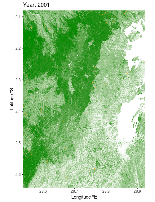
Deforestation of protected forest areas during the period of 2001 to 2020 in the eastern part of the Kahuzi-Biéga National Park (Source: Hansen et al. 2013, © Laura Summerauer
As we fly from Rwanda's capital Kigali to the Kivu region in eastern Democratic Republic of the Congo, our route stretches over a hilly landscape covered in a mosaic of small plots of cassava, corn, sweet potatoes, bananas, millet, beans, and vegetables, as well as large tea plantations. However, what looks beautiful from the air is often a different reality on the ground. Eastern Congo is one of the poorest regions in the world and has been marked by violent political unrest over the past 30 years (Rwandan Genocide, Congolese Civil War).
In the highlands of the Kivu region, the population density has risen sharply during these crisis years. This is especially evident along the eponymous Lake Kivu, where many smallholders live and practice subsistence farming. While most of the slopes in Rwanda have been terraced with financial support from government and international aid, little investment has been made in agriculture on the opposite side of the lake in the Democratic Republic of the Congo. As a result of the rising population pressure, deforestation and agriculture are carried out on very steep slopes, making the soil very susceptible to erosion. The fertile topsoil, enriched with organic carbon and plant nutrients, is eroded during heavy rains and washed out into the valleys below. What remains on the slopes for agriculture is often nutrient-poor subsoil. In steep fields, the entire subsoil can even erode down to the bedrock, making it almost impossible for crops to grow.
Herein exists a vicious cycle of deforestation and arable farming: due to bad or missing infrastructure, there is hardly any protection against erosion; the soils therefore often degrade quickly and yields fall. This in turn increases the pressure to clear more forest. Compounding the problem is the fact that charcoal is the primary energy source in households. The wood from trees in old-growth natural forests is particularly popular for making charcoal and fetches better market prices, which accelerates illegal logging. In addition to the negative impacts on human wellbeing, deforestation also has a large impact on functioning of local ecosystems and survival of wildlife. The logical consequence of increasing deforestation in mountain rainforest areas is the loss of habitat for the local gorilla populations (Grauer's gorillas and mountain gorillas) and the loss of biodiversity in general.
Given the intersecting and often incompatible goals of nature conservation, agriculture, and indigenous peoples, it is becoming increasingly difficult to find a satisfactory conflict-free solution for all parties involved. Unfortunately, this often means that the accelerated logging of protected forests continues unabated (see animated map).
Scientific research in the area offers a window into potential solutions or at least variables to track the cascade of effects from deforestation and erosion. The exposed and deforested steep slopes are open to tropical torrential downpours, which are the main cause of soil erosion in the Kivu region. In a study published in Progress in Physical Geography, a research team led by the Goma Volcano Observatory and the Catholic University of Louvain, Belgium, has now for the first time been able to assess precipitation erosivity more accurately for the region. They found that both the amount of rainfall and the altitude of the affected areas are crucial (Bagalwa et al. 2021).
Another problem for deforested areas is that carbon compounds from deeper soil layers that are thousands of years old are microbially decomposed and released into the atmosphere as CO2 (Drake et al. 2019). The consequences are far-reaching: the released CO2 contributes to the greenhouse effect in the atmosphere and the decomposed organic matter is lost, which is also necessary for general soil health.
To better understand the soil processes in the humid African tropics and the effect of land use change, large-scale soil analyses present an important starting point. Infrared spectroscopy has become increasingly popular in recent decades as a low cost and simple method to measure carbon, plant nutrients, and many other mineral soil properties. Summerauer et al. (2021) have created a database of soil spectra for Central Africa to make future soil analysis cheaper, faster, and easier for the local research community to access.
In summary, erosion reduction and sustainable soil fertility management allow for already deforested areas to maintain crop production or even increase yields while staving off the need for further deforestation and land-use conversion. Meanwhile, investments in more efficient fuel sources for cooking need to be made in order to reduce the illegal harvesting of protected trees for charcoal production. Such measures are crucial to maintain biodiversity, ensure species protection and an increase in numbers, especially within gorilla populations.
Laura Summerauer and Matti Barthel
ReferencesBagalwa, R. M. et al. (2021): Spatial and seasonal patterns of rainfall erosivity in the Lake Kivu region: Insights from a meteorological observatory network. Progress in Physical Geography: Earth and Environment 45 (6), 866-884 doi.org/10.1177/03091333211001793
Drake, T. W. et al. (2019). Mobilization of aged and biolabile soil carbon by tropical deforestation. Nature Geoscience 12, 541-546 doi.org/10.1038/s41561-019-0384-9
Hansen, M. C. et al. (2013): High-Resolution Global Maps of 21st-Century Forest Cover Change. Science 342, 850-855
Summerauer, L. et al. (2021): The central African soil spectral library: a new soil infrared repository and a geographical prediction analysis. SOIL 7, 693-715 doi.org/10.5194/soil-7-693-2021