
Mount Tshiaberimu - the Science behind the Mountain of Spirits
Categories: Journal no. 60, Gorilla Journal, Gorilla Numbers, Censuses, Protective Measures, Democratic Republic of the Congo, Mt. Tshiaberimu, Grauer's Gorilla
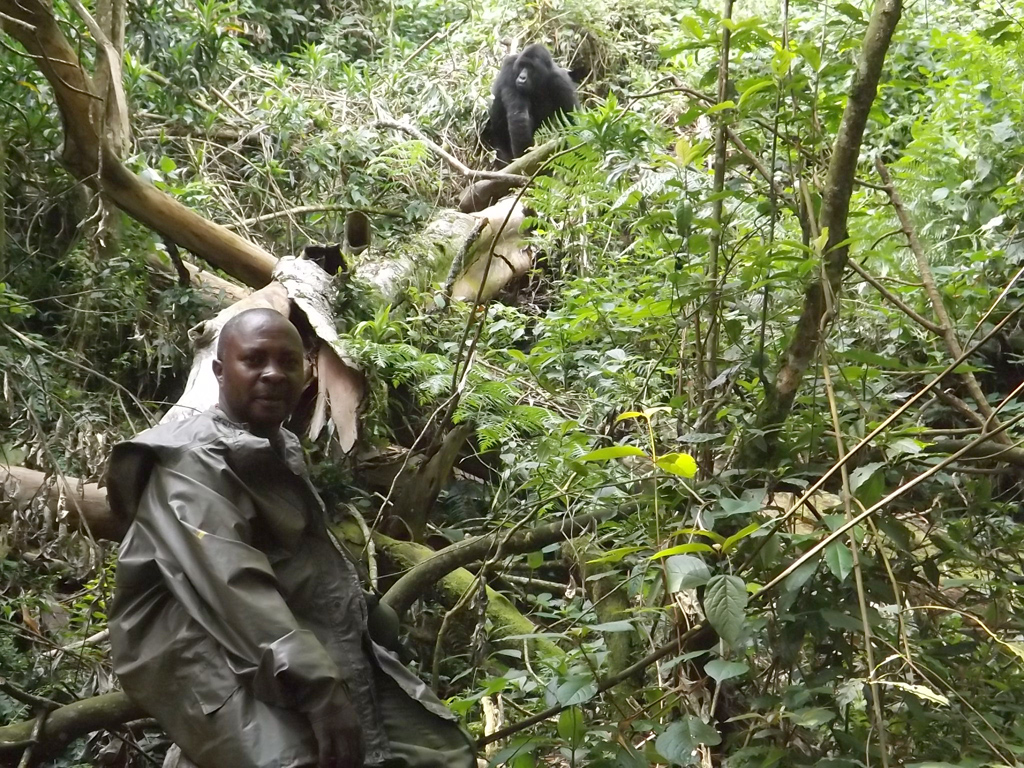
Jean Claude Kyungu introduces Mukokya to tourists in 2010 (© Jean Claude Kyungu)
The northern sector of Mount Tshiaberimu is an integral part of the Virunga National Park (VNP), the west is adjacent to Lake Edward in North Kivu Province, and the east is located in the Democratic Republic of the Congo. Its geographical coordinates are 0° 9'-0° 11' south and 29° 24'-29° 31' east. It reaches an altitude of 3117 m and covers an area of 60 km² of which 7 km² have already been deforested by the extension of cultivation. Gorillas exploit most of the habitat between 2650 and 2950 m.
Mount Tshiaberimu has an equatorial mountain climate type. Its climate reflects its location on the Equator and its high altitude. The vegetation is predominantly Afro-montane forest and changes composition according to altitude.
Mount Tshiaberimu in the Historic Context
According to the history of the migrations of the Bantu peoples, the Wanandes (Bayira) among them, Mount Tshiaberimu was discovered around about the sixteenth century, after the tribes had crossed the Semliki River, then called Kalemba ("snaking rope"). Stanley, among the first European explorers to arrive, wanted to know the name of the river and asked a fisherman who was carrying a closed bag. The fisherman, believing that he was being asked about the contents of his bag, answered "SIMULIKI" or "THERE IS NOTHING". The explorer duly wrote down Semliki as the name of the river, and so it remains to this day. Stanley camped at a site dominated by tall trees; 'Stanley's tree' still stands today on the west coast of Lake Edward between Vuholu and Kisaka.
The Yira people crossed the Kalemba River from Uganda on Mughongo wa ndioka ("the dragon's back"), actually a large rock that breaks the surface of the water and separates Lake Edward from the Semliki River at Ishango in the Virunga National Park, where archaeologists discovered Ishango Man (Mashauri 1980).
After crossing the Semliki River, the Chief of the Baswagha clan temporarily settled his people on Mount Tshiaberimu, where they discovered a type of strong animal that they had never seen before. Whenever they encountered these animals, they would threaten the humans by hitting themselves on their chests. The Chief considered these animals to be spirits. Thus, the mountain was called Kitwa eky'evirimu in the local dialect ("mountain of the spirits") which became Tshiabirimu (or Tshiaberimu), although the local spelling remains Ekyavirimu. The spirit animals were, of course, the gorillas.
Mount Tshiaberimu: from the Traditional Spirits to an Understanding of Science
Mount Tshiaberimu was incorporated into the Virunga National Park in 1938 due to the presence of gorillas, which were discovered there by Sir Johnson in 1931, according to an ICCN report (ICCN pers. comm.).
George B. Schaller visited Mount Tshiaberimu for 2 weeks in 1959 and found 4 groups of gorillas. He estimated their number to be between 30 and 40 individuals. He studied the gorillas' diet and how much time the gorillas spent in the various vegetation zones. Since then, work has focused on the parasitology of the gorillas including the determination of endoparasites (Masika et al. 2010), and on ape eco-ethology and some aspects of feeding behaviour (Chifundera et al. 2003). The information about gorilla numbers at this site comes from scientific missions conducted by Schaller in 1959 (Schaller 1963), Conrad Aveling in 1986 (Aveling & Aveling 1989) and Tom Butynski and Esteban Sarmiento in 1995 (Sarmiento et al. 1996). The number of gorillas was reported to be between 30 and 40 in 1959, 20 in 1986, 14 to 16 in 1995, and 11 in 2003, with no details given about group composition. According to Chifundera, the population rose to 21 (Chifundera et al. 2004) but this last number is disputed (Sikubwabo, unpubl.). The 2006 census (Kyungu & Kataomba 2007) estimated 13 individuals.
The reduction in numbers to 12 by mid-1997 (Sikubwabo, unpubl.) can be attributed to deforestation and hunting. Mount Tshiaberimu was invaded for mining and cultivation. According to Dajoz (1980), density-dependent factors modify the rate of population growth by acting on the birth rate or the death rate. Generally speaking, the growth rate decreases as density increases. He also mentions that in some species, the reproductive rate decreases with decreasing number of fertile females, but also with the presence of disease. The former is certainly the case of the Tshiaberimu gorillas, as the number of females has currently reduced to two.
A New Project Comes to Life
The 1995 census shed more light on the situation of Mount Tshiaberimu's fauna and flora. This census was funded by Zoo Atlanta, Berggorilla & Regenwald Direkthilfe (B&RD) and the Dian Fossey Gorilla Fund, London (now The Gorilla Organization). This census laid the foundation for a new gorilla conservation project. The equipment required for the project to start was provided by B&RD. The project was set up to safeguard the small, isolated population of gorillas under threat by human activities.
Project staff were recruited from villages around Mount Tshiaberimu. The rangers conduct patrols and monitoring. The workers set up transects. The Social Assistant is responsible for the sensitization of the population. The duties of the Assistant Conservator are administrative facilitation, sensitization and participation in patrols. The Project Director is the administrative and scientific manager, responsible for ensuring the smooth operation and management of the project according to the terms of reference defined by the project partners (The Gorilla Organization, B&RD, etc.).
Monitoring and Tracking of Gorillas
In 1997 and 1998, Claude Sikubwabo and the late Vital Katembo, with the support of B&RD, organised training for rangers in monitoring, anti-poaching and the identification of vegetation types. In early 2000, Claude Sikubwabo took part in the initiation of gorilla habituation, except for a brief period when he led the IUCN Parks for Peace Project (PPP).
Between 1997 and 2007, monitoring was carried out by 7 well-trained rangers working in two groups. Monitoring was supervised by the rangers Sindani and Mahamba Paluku. Two groups of gorillas were followed, Nzanzu-Lusenge and Tsongo. The two groups consisted of 11 and 4 individuals. According to Chifundera, there were also 3 solitary males and the group contained 3 infants, and the Lusenge group split in two subgroups in 2002 (Chifundera 2004). During monitoring, data were recorded on habitat (geographic coordinates, altitude, climate and vegetation) and on the behaviour of the group members, especially on interactions between the dominant males. Feeding behaviour and how much time the gorillas spent in different activities were studied in more detail. For purposes of habituation, the rangers tried to make contact with the gorillas on a daily basis.
Between 1998 and 2002, a Magellan 315 GPS was used to collect geographical coordinates; between 2002 and 2008, a Garmin 12XL was used; since 2008, a Garmin map 62 has been used. The coordinates are collected for each location where gorillas, their droppings or their nests are encountered. This information provides a set of data that indicate how gorillas occupy and use their habitat. They also show the movements of gorillas around the site. Altitude data can be used to identify vegetation zones. The gorillas of Mount Tshiaberimu travel at an altitude between 2650 and 2950 m.
The Nzanzu-Lusenge group spent the night in two sub-groups, one with 5 individuals and the other with 6. This might have been an indication that the group could split along these lines in the near future. The silverback spent the night with the sub-group of 5. The nests were arranged in an eastward direction. Some nests were built in trees. Interactions (i.e. fights) between the two silverback males of the two groups were observed in December 2001 and January 2002. This family disappeared in 2012. Only two of its members, Mukokya and Mwengesyali, were seen to move to another group.
The Development of Gorilla Monitoring Activities over Time
On 26 April 1998, the late Vital Katembo, then Project Manager, initiated gorilla monitoring. The team of trackers and rangers was installed in Kalibina, which is now the Gorilla Tracking Research Centre. The team members were Paluku Mahamba (park ranger and monitoring officer), Kakule Musavuli (tracker), Katsuva Kitsumbura (tracker), Kambasu Kasusu (tracker), Kavembere Kahumba (tracker) and Mumbere Katu (logistics officer). The trackers were assigned the task of tracking the Lusenge group, consisting of 11 individuals including juveniles. There were also 2 known solitary gorillas. In order to locate the solitary gorillas, the number of trackers had to be increased, so Kakule Nyerere and Katsuva Kayisumba joined the team for this purpose. Monitoring was arduous and required endurance, but results were obtained. As habituation progressed, the gorillas turned out to be not as wild as had been believed.
Despite the constraints during the period of war, the monitoring team was regularly provided with rations.
When the Project Manager left for study in 2002, a replacement director was appointed, Mr. Chifundera Kusamba. Activities continued throughout, mainly monitoring but many research activities. During this period, the following events took place:
- After several interactions, the Lusenge family was driven out and replaced by the Kipura group, led by the silverback Tsongo.
- New babies were born, including Mwasananyinya, Kambula and Musanganya.
- The solitary males Kanindo and Katsavara were followed and habituated.
- The number of trackers had to be increased once again and Kambale Towaluso and Kahindo Kivikwamo joined the monitoring team, followed by Kambasu Vihugho; Kihurania and Paluku Kakome joined in 2004.
In March 2005, Project Director Chifundera was assigned to other duties and replaced by Jean Claude Kyungu. The monitoring team was reinforced further in order to locate other solitary gorillas: Sinaminya Emmanuel, Paluku Kihunirwa, Vundama and Kambale Sivyaghendera joined the team at that point. During this period, a first scientific census of the Tshiaberimu gorillas was carried out by various researchers and trackers. A very important event was the birth of a baby in the Kipura group on 5 August 2006. It was named Musomboli to mark the election that was going on at the time. Another baby, Mwavita, was born in 2007; sadly, this one was found dead following an interaction. A third infant was born in 2009 and subsequently crushed to death by the mother Mwengesyali.
The Development of Patrols
Prior to the start of the project: The forest of Mount Tshiaberimu was watched over by four ranger posts: the posts at Muramba and Kyavinyonge, which are located in the south and the north of the eastern part of Tshiaberimu on Lake Edward, and the posts of Camp Ngai and Museya located in the western and north-western part of the forest.
Each post had a well-defined area where they coordinated surveillance and anti-poaching patrols. The patrols had the same objectives as during the time of the project (see below), except that monitoring was not conducted.
During the project: There are two types of patrols: patrols during which the staff overnight in tents, and regular patrols. A 'tent patrol' is carried out once a month and lasts over three days. The rangers on patrol take food with them. The objective of the patrols is to dissuade the local population from entering the park. They combat poaching, gold panning, park encroachment and logging. Patrols help to maintain the integrity of the park's boundaries. Since December 2001, logging and the cutting of bamboo has reduced significantly, but the extension of fields for food crops continues and constitutes a serious problem for the conservation of gorillas and their habitat in the sectors of Vihyo and Mulango wa nyama. Poachers with dogs have been apprehended and taken to Mutsora Headquarters.
While the area of Kalibina was being monitored, rangers also patrolled inside the park. Before the war, the park rangers were equipped with weapons. These were later requisitioned by the local militia, and from then on, the rangers only had machetes or spears to take with them.
The invasion of the park by farmers has been going on for a long time, but with the great number of patrols it has been possible to reclaim some areas of the park, notably in 2002, with support from the regular army.
When the project started in 1996, The Gorilla Organization envisaged the construction of three patrol posts (PP). These were Burusi PP, Camp Ngai (this existed before, but had been destroyed during the war) and Kitolu PP, in addition to Kalibina Centre, where all houses were semi-permanent. This construction was required due to the increase in the number of patrol staff, which arose from the need to cover all sectors of the park. Both types of patrols were intensified. Equipment and food rations for the patrols were provided by the project. In 2007, to maintain continuous monitoring and to reach even the most remote corners, The Gorilla Organisation considered building two houses made from wood planks at Kikyo PP. Mulango Wanyama PP was erected in an initiative by PEVi/KACHECHE (WWF), one of ICCN's partners.
Since Tshiaberimu is a sub-station, four Conservators succeeded one another in maintaining order and in collaborating with the project managers. These were: the late Kasereka Bayihota based in Kyavinyonge (1998-2000), the late Kamate Malikewa (2000-2001 and 2006-2009) and Beghene Katsumbano Joseph (2002-2005); these were followed by Kyungu Kasolene (2005-2014). Jean Claude Kyungu was project manager from 2005 to 2009 and then appointed Conservator. He had the dual role of project manager and Conservator from 2010 to 2012 and continued as Conservator from 2012 to 2014. The project ended in 2012.
Relationship between Project and Authorities
We have met three times with the ministers and heads of divisions (RCD-KML Kisangani) responsible for nature conservation, the governor of North Kivu Province in Beni and the mayor of Butembo. After the reunification of the Province and the Republic, new strategies were developed for collaboration with Goma and Kinshasa (Provincial and National Deputies). In Kyondo, we are in regular contact with the group and community leaders. During all these meetings, we explained the objectives of the project and at the same time solicited the support of the communities for the implementation of conservation activities on Mount Tshiaberimu. During some of the visits, we are accompanied by Mushenzi Norbert, Director of the PNVi Northern Sector. The authorities have readily participated in the meetings and in workshops, which were organized jointly by The Gorilla Organisation, WWF/PEVi and ICCN. They have always promised to support the project. However, everybody we met has called for socio-economic development projects around Mount Tshiaberimu.
Relationship between Project and the Local Population
Contacts with the local population have been facilitated by various persons and organisations. The members of the Coordinating Committee for the Revival of Population Migration and Spatial Planning (RMIP/AT) visited Burusi in December 2001 and January 2002. They held sensitization meetings, in which 180 villagers participated. However, some people and associations initially remained hostile to nature conservation activities in the PNVi Northern Sector, such as SYDIP (Union for the Defence of Farmers' Interests) and individuals such as Ngovi de Nguli, Kadembi, Kasomya and Abel from Kabeka village, who continued to encourage people to enter the park and commit acts of vandalism. However, these relationships quickly improved and were maintained at a good level between 2006 and 2014.
Conservation awareness campaigns were carried out between 2002 and 2005 by the Social Assistant Ms Kave Aveline, between 2005 and 2009 by Paluku Vhosi and between 2010 and 2014 by Kasereka Vatenaye. The Conservator visited the villages several times to explain to the population the merits and benefits of the project and of gorilla conservation. The association SAGOT (Friends of Gorillas) requested to collaborate with the project on environmental communication in school campaigns. The association Cultural Unity (ACU), led by Mr. Apollinaire, composed and recorded songs dedicated to the conservation of the gorillas of Mount Tshiaberimu.
These sensitization campaigns focused on:
- Educating the population through workshops, meetings, cultural and sports activities
- Radio broadcasts
- Various training courses on animal husbandry, agriculture, wildlife and human health
- Support for the project and the neighbouring communities. From 2008, B&RD provided funds to supplement the food rations and to purchase equipment for the trackers. A house made of wooden planks, 12 x 6 m in size, was built in Burusi with B&RD funds. Part of this house was used as the Burusi project office; another part served as accommodation for non-local project staff. Office equipment was provided and mattresses and beds were purchased.
- B&RD support in Tshiaberimu: construction of the PP Burusi office in 2012, support for fruit cultivation by the communities, equipment for the trackers.
After the Project
The project ended abruptly without an exit strategy. Bonuses, salaries and all support were terminated abruptly. The well-trained personnel (trackers) were abandoned in the field. B&RD, which was already actively involved on the ground, found itself alone and had to take charge of the Mount Tshiaberimu site. It was also a time of serious problems, including incursions by insurgents. Politicians greedy for power supported the termination of the project, reasoning that the European partners had found that the gorillas could no longer survive on the site. The number of gorillas had indeed dropped dramatically to six individuals with only two females, one of which was old and no longer able to reproduce. The politicians were campaigning for the redistribution of the Mount Tshiaberimu land to the people.
After B&RD was contacted, the organisation intensified its support for the site, which it continues to this day. It remains a relentless struggle to save the gorillas during a time in which rangers have been killed, trackers injured and forced to flee the area, and a gorilla has disappeared. Several development projects have been carried out around Mount Tshiaberimu and this has also helped to sensitize and bring development to the population. The ICCN, which withdrew from the site for a few months between 2016 and 2017, strengthened its team and consolidated its interventions. Currently, the situation is stabilizing and the birth of a baby gorilla at the end of 2019 is particularly good news.
Jean Claude Kyungu Kasolene and Claude Sikubwabo Kiyengo
References
Aveling, C. & Aveling, R. (1989): Gorilla conservation in Zaire. Oryx 23, 64-70
Chifundera, K. et al. (2003): The Mount Tshiabirimu in the Albertine Rift: biodiversity, habitats and conservation issues. Unpublished report, Dian Fossey Gorilla Fund Europe, 231 p.
Dajoz, R. (1980): Précis d'écologie, 5th edition. ed. Bordas, Paris, 505 p.
Kyungu, K. & Kataomba, K. (2007): Inventory of Mount Tshiabirimu Mammals, Mount Tshiabirimu Gorilla Conservation Project. Mission report, unpublished, 32 p.
Mashauri, M. (1980): Les migrations yira: rivalités d'occupation des terres à haute altitude. In: Annals of the Faculty of Science, UNILU, PUL Vol. 2.p.
Sarmiento, E. et al. (1996): Mission d'exploration scientifique au Mont Tshiabirimu. ICCN, report, unpublished, 12 p.
Schaller, G. B. (1963): The Mountain Gorilla: ecology and behavior. University of Chicago Press, 390 p.
Scientific Research
During the project period, several studies were conducted on Mount Tshiaberimu. There has been spontaneous work by KAUR (University of Virginia) on malaria in gorillas and by MIKE (Mountain Gorilla Veterinary Project) on gorilla haematology. Below is a list of other scientific work, most of which has already been published.
Baluku, B. et al. (2010): Contribution à l'étude verticale des amphibiens du Mont Tshiabirimu, Parc National des Virunga, Nord-Kivu, RD Congo. Mémoire de Licence, inédit, UOR, 41 p.
Bapeamoni, A. et al. (2008): Inventaire ornithologique du Mont Tshiabirimu (R. D. Congo). GO, rapport inédit, 80 p.
Butynski, T. M. & Sarmiento, E. E. (1995): On the brink: The Gorillas of Mont Tshiaberimu, Zaire. Kenya Past and present 27 (1), 17-20
Chifundera, K. et al. (2003): The Mount Tshiabirimu in the Albertin Rift: biodiversity, habitats and conservation issues. Rapport inédit, Dian Fossey Gorilla Fund Europe, 231 p.
Chifundera, K. et al. (2004): Inventaire des amphibiens au Mont Tshiabirimu: cas du marais d'altitude de Kalibina et de la vallée de Burusi et ses environs. TFC inédit, ISEC/KAYNA, 35 p.
Kambale, S. (2018): Diet selection strategies of Grauer's gorillas (Gorilla beringei graueri) in relation to nutritional benefits and exposure to hepatotoxic phytochemical in Mount Tshiabirimu Forest, Virunga National Park, DRC. Dissertation, Ms, Makerere University, inédit, 73 p.
Kasika, L. et al. (2011): Etude de l'influence de l'activité humaine sur les aires protégées en Territoire de Beni et Lubero: cas du Mont Tshiabirimu "secteur Nord du Parc National de Virunga" en République Démocratique du Congo. Parcours et Initiatives Vol. 9, 92-124
Kigotsi, K. et al. (2009): problématique de la gestion des aires protégées face à l'émergence socio-économique des populations riveraines en province du Nord-Kivu. Cas du Mont Tshiabirimu de 2002 à 2008. Mémoire inédit, UNIGOM, 86 p.
Kyungu, K. & Kahambu, M. (2010): Etude du rythme d'activités journalières des Cercopithecidae au Mont Tshiabirimu. TFC inédit, UOR, 40 p.
Kyungu, K. & Kavugho, N. (2006): Les paysans face à la gestion des potentialités hydrauliques du Mont Tshiabirimu en territoire de Beni-Lubero, TFC inédit, ISDR/GL, 54 p.
Kyungu, K. et al. (2008): Dépistage des parasites gastro-intestinaux au Mont Tshiabirimu et ses environs. Rapport inédit, ICCN-GO, 25 p.
Kyungu, K. J.-C. et al. (2013): Contribution to the analysis of the viability of a small gorilla population, Gorilla beringei graueri (Hominidae, Primates), by modeling and simulations of the Mount Tshiabirimu ecosystem, Virunga National Park in the Democratic Republic of the Congo. primatologie.revues.org/1453
Kyungu, K. J.-C. et al. (2019): Impacts des pressions anthropiques sur l'habitat de la population de gorilles de Grauer dans le Grand Paysage Virunga: comprendre les origines des pressions sur l'habitat des gorilles de Tshiabirimu (République Démocratique Du Congo). IOSR Journal of Humanities And Social Science (IOSR-JHSS)
Masika, L. et al. (2010): Prévalence des helminthes chez les gorilles du Mont Tshiabirimu. Mémoire de Doctorat en Médecine Vétérinaire, inédit, Université Catholique du Graben, 65 p.
Ngbolua, K. et al. (2014): Phytochemical investigation and TLC screening for antioxidant activity of 24 plant species consumed by the Eastern Lowland Gorillas (Gorilla beringei ssp. graueri : Hominidae, Primates) endemic to Democratic Republic of the Congo. Journal of Advancement in Medical and Life Sciences 1 (3), 1-6
Roy, J. et al. (2014): Recent divergences and size decreases of eastern gorilla populations. Biology Letters 10, 11
Sarmiento E. E. & Butynski, T. M. (1997): Population and Habitat Viability (PHV) for Gorilla gorilla beringei: Preliminary report on the Mt Tshiaberimu survey, June 28-July 17. Kampala Uganda